U.S. Gulf Offshore Oil Production: Moving into Deeper Water Horizons

Downloads
Overview

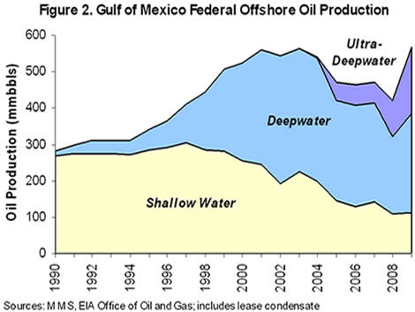
Offshore oil production in the U.S. portion of the Gulf of Mexico represents 30 percent of total U.S. oil production, with 35.6 million acres (an area the size of Maine) under active lease. As oil reserves in shallow water are declining, production is moving into ever-deeper water, incurring greater risk. The Deepwater Horizon disaster illustrates the safety, economic, and environmental risks inherent in this trend. Likewise, it illustrates why lawmakers need to enact policies that move the United States in the direction of cleaner, safer energy sources and caps harmful pollution that causes climate change.
Data Sources
- Oil & gas platforms, pipelines, leases: US Department of the Interior Minerals Management Service
- State boundaries, rivers, urban areas: ESRI Data & Maps collection
Copyright
This work is licensed under the Creative Commons Attribution License. Cite "World Resources Institute."
Other Featured WRI Maps
[inlineview term=4359 theme=list sort=created order=desc]
Maps From Other Organizations
- NOAA Gulf Response portal
- New York Times Oil Spill Tracker
- ESRI Gulf of Mexico Oil Spill Portal
- Google Crisis Response: Gulf of Mexico Oil Spill
- Defenders of Wildlife Gulf Oil Spill Response and Recovery
This map is part of a continuing project to produce maps that shed light on significant environmental issues throughout the world.